
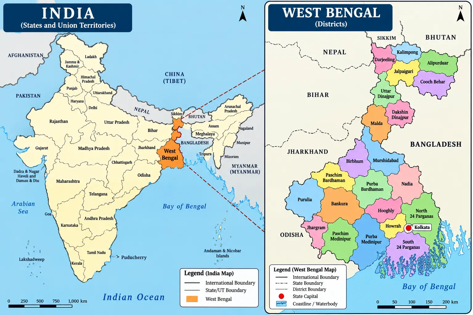
Physiographic Divisions of West Bengal: From the snow-clad peak of Sandakphu in the north to the tidal mangrove channels of the Sundarbans in the south, West Bengal features one of the most physically diverse terrains in eastern India. The physiography of West Bengal canbe devided into 7 regions:
- Northern Mountainous Region
- Terai–Duars Region
- North Bengal Plains
- Western Plateau and Highlands
- Rarh Plain
- Ganga Deltaic Plain and Sundarbans
- Coastal Plain
1. Northern Mountainous Region
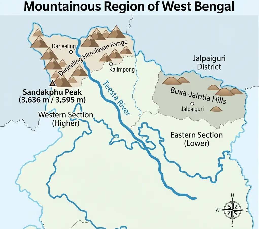
The Northern Mountainous Region occupies the extreme northern section of West Bengal and forms an integral part of the Eastern Himalayas. It primarily encompasses the districts of Darjeeling and Kalimpong, along with adjoining northern foothill areas.
                  EASTERN HIMALAYAS (WEST BENGAL)
                                │
        ┌───────────────────────┼───────────────────────┐
        ▼                       ▼                       ▼
 Singalila Range      Darjeeling Ranges          Kalimpong Hills
 (Sandakphu: 3,636m)            │                       │
                                ▼                       ▼
                           Teesta River         Sinchula & Buxa Hills
Mountain Systems
- Singalila Range: Forms the border between West Bengal and Nepal.
- Darjeeling Himalayan Ranges: Main ridge running through Darjeeling.
- Kalimpong Hills: Located east of the Teesta River gorge.
- Sinchula Range & Buxa Hills: Bordering Bhutan in the northeast.
Sandakphu: The Peak of West Bengal
- Elevation: 3,636 metres
- Range: Singalila Range
- District: Darjeeling
- Physiographic Region: Northern Mountainous Region
- Mountain System: Eastern Himalayas
- Key Viewpoint: Sandakphu is famous for panoramic views of major Himalayan peaks, including Kanchenjunga, Everest, Lhotse, and Makalu.
Teesta River & Northern Physiography
The Teesta River divides the northern region physically:
- West of Teesta: Terai
- East of Teesta: Duars
Summary
| Fact | Answer |
| Himalayan System | Eastern Himalayas |
| Highest Point of West Bengal | Sandakphu |
| Elevation of Sandakphu | 3,636 m |
| Range Containing Sandakphu | Singalila Range |
| District of Sandakphu | Darjeeling |
| Important River | Teesta |
| West of Teesta | Terai |
| East of Teesta | Duars |
| Important Eastern Hill System | Sinchula / Buxa Hills |
2. Terai–Duars Region
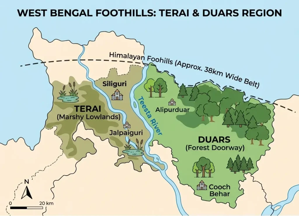
Located directly south of the Himalayan foothills, the Terai–Duars is a moist foothill belt created by mountain wash and sediment runoff.
Terai (West of Teesta) <—> Duars (East of Teesta)
The Terai Tract
The Terai is the wet, humid foothill belt lying mainly west of the Teesta River.
- Low-lying foothill tract
- Humid and marshy environment
- High soil moisture & high groundwater table
- Covered by tall grasses, riverine deposits, and dense forests
- Standard Dimensions: A roughly 38-km-wide north–south belt at the Himalayan base.
The Duars (Dooars) Tract
The Duars lies mainly east of the Teesta River. The term Duars originates from ‘doors’ or ‘gateways’—referring to the historic routes into Bhutan.
Duars = Gateway / Doors to Bhutan
- Extent: Stretches from the Teesta River in the west to the Sankosh River in the east.
Important Rivers
- Teesta
- Jaldhaka
- Torsa
- Raidak
- Kaljani
- Sankosh
Wildlife Reserves & Protected Areas
- Jaldapara National Park: Famous for the Great One-Horned Indian Rhinoceros.
- Gorumara National Park: Home to Indian rhinoceroses, elephants, gaurs, and deer species.
- Buxa Tiger Reserve: Located in Alipurduar district; shelters tigers, elephants, leopards, and gaurs.
- Chapramari Wildlife Sanctuary: Located in the core Dooars region.
Terai vs. Duars
| Feature | Terai | Duars |
| Location | West of Teesta | East of Teesta |
| Physical Nature | Wet, humid foothill tract | Eastern Himalayan foothill belt |
| District Alignment | Siliguri / Darjeeling foothills | Jalpaiguri / Alipurduar side |
| Geographic Significance | Himalayan foothill plain | Gateway region toward Bhutan |
3. North Bengal Plains
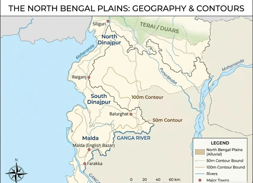
The North Bengal Plains are alluvial plains built up by sediment deposition (sand, silt, clay, and gravel) carried down by northern river networks.
- Key Rivers: Teesta, Torsa, Jaldhaka, Raidak, Kaljani, Mahananda, and Atrai.
- General Relief: Flat, gently sloping, river-built, highly fertile for agriculture, yet flood-prone.
- General Slope: Directs from North to South.
                NORTH BENGAL PLAINS (MALDA DIVISION)
                                │
        ┌───────────────────────┼───────────────────────┐
        ▼                       ▼                       ▼
      BARIND                   TAL                    DIARA
  • East Malda            • North/NW Malda       • South/SW Malda
  • Old Alluvium          • Low & Marshy         • New Alluvium
  • Elevated & Undulating • Flood-Prone          • Flat & Fertile
The 3 Units of Malda
Malda Geographic Structure = Tal + Diara + Barind
1. Barind
- Location: Mainly Eastern Malda
- Characteristics: Elevated, old alluvial surface, undulating relief, and comparatively less flood-prone.
- Formula: Barind = East + Old Alluvium + Elevated
2. Tal
- Location: Mainly Northern & Northwestern Malda
- Characteristics: Low-lying, marshy, poorly drained with numerous depressions (tals), highly flood-prone.
- Formula: Tal = Low + Marshy + North/Northwest Malda
3. Diara
- Location: Mainly Southern & Southwestern Malda
- Characteristics: Formed by younger alluvium, flat, well-drained, highly fertile, and continuously renewed by river floods.
- Formula: Diara = New Alluvium + South/Southwest Malda
4. Western Plateau and Highlands
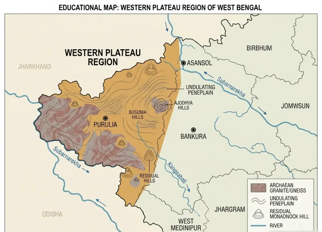
Occupying the western margins of the state, this zone serves as the eastern extension of the Chota Nagpur Plateau.
                 WESTERN PLATEAU & HIGHLANDS
                              │
     ┌────────────────────────┴────────────────────────┐
     ▼                                                 ▼
Geology & Soil                                    Landforms & Hills
 • Ancient Granite & Gneiss                        • Undulating Peneplain
 • Red & Lateritic Soil (Acidic/Iron-rich)        • Ajodhya Hills (Purulia)
 • Mineral Rich (Raniganj Coalfield)               • Gorgaburu Peak (Highest)
Districts Included
- Purulia (Primary district)
- Parts of Bankura, Birbhum, Paschim Bardhaman, Jhargram, and western interior belts.
Geological Makeup & Soil
- Rock Types: Ancient crystalline rocks including Granite, Gneiss, Quartzite, Schist, and associated igneous/metamorphic formations.
- Landform Evolution: Prolonged weathering and erosion have carved this area into an undulating peneplain featuring residual hills, isolated uplands, dissected plateau surfaces, and valleys. Small local hillocks are known as ‘Tila’.
- Soil Profile: Red and Lateritic soil—brownish-red, iron-rich, acidic, with low agricultural fertility.
Landmarks & Resources
- Ajodhya Hills: Dissected upland plateau in Purulia district.
- Gorgaburu: The highest peak of the Ajodhya Hills and the Western Plateau.
- Mineral Resources: Rich in coal, fire clay, china clay, construction stone, and iron-bearing minerals.
- Raniganj Coalfield: One of India’s oldest and major coal fields, situated primarily in Paschim Bardhaman.
Summary
| Feature | Fact |
| Location | Western West Bengal |
| Main District | Purulia |
| Plateau Association | Chota Nagpur Plateau extension |
| Rock Systems | Ancient crystalline rocks |
| Primary Soil | Red and lateritic soil |
| Major Landform | Undulating peneplain |
| Important Hills | Ajodhya Hills |
| Important Peak | Gorgaburu |
| Important Coalfield | Raniganj |
5. Rarh Plain
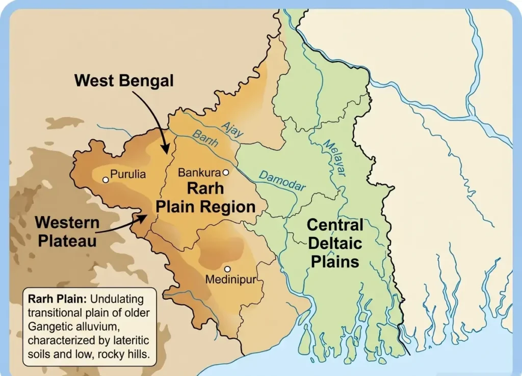
The Rarh Plain is a transitional physiographic belt situated between the rocky Western Plateau and the low-lying Ganga Delta.
Rarh Tract = Lateritic Old Alluvium
Location & Extent
Occurs between the western highlands and the eastern delta, spanning parts of Birbhum, Bankura, Bardhaman, Hooghly, Nadia, Murshidabad, and central-western territories.
Relief & Drainage
- Elevated and undulating landscape compared to the delta.
- Well-drained and less subject to tidal action.
- Key Rivers: Ajay, Damodar, Mayurakshi, Dwarakeswar, and Rupnarayan.
Rarh vs. Delta
| Property | Rarh Plain | Deltaic Plain |
| Alluvium Type | Old lateritic alluvium | Younger / recent fine alluvium |
| Topography | Undulating & elevated | Very flat & low-lying |
| Hydrology | Well-drained, minimal tidal influence | High tidal influence, flood-prone |
| Region | Western & Central Bengal | Southern & Eastern Bengal |
6. Ganga Deltaic Plain and Sundarbans
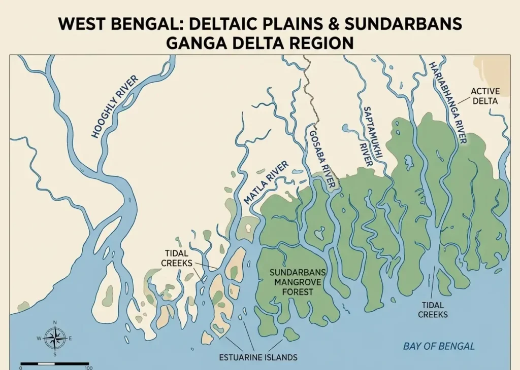
Forming part of the vast Ganga–Brahmaputra–Meghna Delta, southern West Bengal is shaped by fluvial and tidal sedimentation, island formation, and erosion.
Drainage System
- Primary Distributaries: Bhagirathi, Hooghly, Matla, Gosaba, Saptamukhi, Jamira, Hariabhanga, Raimangal, and Bidyadhari.
- The Hooghly River: The main western distributary of the Ganga system flowing through West Bengal. Kolkata sits along its banks, while Haldia dominates its estuarine mouth. Historic for shipping, navigation, and industry.
Hooghly –> Western Ganga Distributary –> Kolkata Port –> Haldia Estuary
The Sundarbans Ecosystem
Occupying the southernmost edge of the delta along the Bay of Bengal, the Sundarbans is the world’s largest contiguous mangrove forest.
Sundarbans –> World’s Largest Mangrove Ecosystem
- Vegetation: Named after the Sundari Tree (Heritiera fomes). Other key mangroves include Goran, Gewa, Keora, and Nypa palm (Golpatta).
- Fauna: Royal Bengal Tiger, estuarine crocodile, spotted deer, wild boar, fishing cat, and aquatic bird species.
- Landforms: Tidal creeks, tidal channels, mudflats, estuarine islands, and tidal swamps.
                  SUNDARBANS WORLD HERITAGE DATES
                                │
        ┌───────────────────────┴───────────────────────┐
        ▼                                               ▼
   WEST BENGAL / INDIA                             BANGLADESH
Sundarbans National Park                     The Sundarbans
Inscribed: 1987                              Inscribed: 1997
Note:
- 1987: Sundarbans National Park (India) inscribed as a UNESCO World Heritage Site.
- 1997: The Sundarbans (Bangladesh) inscribed as a UNESCO World Heritage Site.
7. Coastal Plain
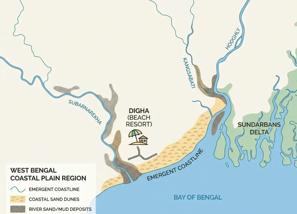
The Coastal Plain stretches along the southern margin of West Bengal bordering the Bay of Bengal for approximately 220 km. Key districts include Purba Medinipur, South 24 Parganas, and Sagar Island.
                     WEST BENGAL COASTLINE (~220 km)
                                    │
         ┌──────────────────────────┴──────────────────────────┐
         ▼                                                     ▼
Hooghly Estuarine Plain                             Medinipur Coastal Plain
  • Macro-Tidal (> 4m range)                          • Meso-Tidal (2–4m range)
  • Mangroves, creeks, estuarine islands             • Sandy beaches & sand dunes
  • Example: Sagar Island                             • Example: Digha, Mandarmani
Coastal Sub-Divisions
1. Hooghly Estuarine Plain
- Tidal Type: Macro-tidal (Tidal range greater than 4 metres)
- Environment: Dense tidal creeks, mudflats, estuarine islands, and mangrove patches.
- Key Location: Sagar Island and the Hooghly estuarine complex.
2. Medinipur Coastal Plain
- Tidal Type: Meso-tidal (Tidal range 2 to 4 metres)
- Environment: Sandy beaches, coastal sand dunes, and tidal flats.
- Key Towns/Resorts: Digha, Shankarpur, Junput, Tajpur, and Mandarmani.
Coastal Landforms & Hazards
- Landforms: Sandy beaches, sand dunes, tidal flats, mudflats, coastal marshes, estuaries, and creeks.
- Environmental Hazards: Tropical cyclones, storm surges, coastal flooding, shoreline erosion, tidal inundation, and salt intrusion into soils.
Physiographic Divisions of West Bengal- Facts
| Division / Topic | Must-Know WBCS Fact |
| Northern Mountains | Part of the Eastern Himalayas |
| Highest Point | Sandakphu (3,636 m) |
| Sandakphu Details | Singalila Range, Darjeeling District |
| Terai | Foothill tract West of Teesta River |
| Duars | Foothill tract East of Teesta River |
| Duars Etymology | Means ‘Doors’ or ‘Gateways’ to Bhutan |
| Rhino Habitat | Jaldapara National Park (Dooars) |
| Tiger Habitat | Buxa Tiger Reserve (Alipurduar) |
| North Bengal Plains | Riverine Alluvial Plain |
| Malda Units | Tal + Diara + Barind |
| Barind Unit | Eastern Malda, elevated old alluvium |
| Tal Unit | Northern/NW Malda, low-lying marsh |
| Diara Unit | Southern/SW Malda, fertile new alluvium |
| Western Plateau | Extension of Chota Nagpur Plateau |
| Plateau Soils | Red and lateritic soil |
| Purulia Landmark | Ajodhya Hills |
| Ajodhya Highest Peak | Gorgaburu |
| Plateau Topography | Undulating peneplain with residual hillocks (Tilas) |
| Major Coalfield | Raniganj (Paschim Bardhaman) |
| Rarh Plain | Old lateritic alluvial plain |
| Rarh Rivers | Ajay, Damodar, Mayurakshi, Dwarakeswar, Rupnarayan |
| Main Ganga Branch | Hooghly River (Western Distributary) |
| Sundarbans Ecosystem | Tidal Mangrove Forest |
| Sundari Scientific Name | Heritiera fomes |
| Sundarbans Mascot | Royal Bengal Tiger |
| UNESCO Inscription | 1987 (Sundarbans National Park, India) |
| Total Coastline | ~220 km along the Bay of Bengal |
| Hooghly Estuary Tide | Macro-tidal (Range greater than 4 m) |
| Medinipur Coastal Tide | Meso-tidal (Range 2 to 4 m) |
| Major Coastal Resort | Digha (Purba Medinipur) |
Physiographic Divisions of West Bengal-Question Bank
Section 1: Northern Mountains
- Q: What is the highest point of West Bengal?
A: Sandakphu - Q: What is the elevation of Sandakphu?
A: 3,636 m - Q: Sandakphu belongs to which mountain range?
A: Singalila Range - Q: Sandakphu is located in which district?
A: Darjeeling - Q: Northern West Bengal belongs to which Himalayan system?
A: Eastern Himalayas
Section 2: Terai–Duars
- Q: Which river separates the Terai and Duars?
A: Teesta River - Q: The Terai lies on which side of the Teesta?
A: West - Q: The Duars lies on which side of the Teesta?
A: East - Q: What does the term ‘Duars’ mean?
A: Doors or Gateways - Q: The Duars acts as a gateway to which neighboring country?
A: Bhutan - Q: What animal is Jaldapara National Park famous for?
A: One-horned Indian rhinoceros - Q: Buxa in Alipurduar is primarily designated as what type of reserve?
A: Tiger Reserve
Section 3: North Bengal Plains
- Q: What is the dominant geological character of the North Bengal Plains?
A: Alluvial - Q: What are the three physiographic sub-units of Malda district?
A: Tal, Diara, and Barind - Q: Which unit of Malda is low-lying and marshy?
A: Tal - Q: Which unit of Malda is composed of fertile new alluvium?
A: Diara - Q: Which unit of Malda consists of elevated, undulating old alluvium?
A: Barind
Section 4: Western Plateau
- Q: The Western Plateau of West Bengal is an extension of which plateau?
A: Chota Nagpur Plateau - Q: What is the dominant soil type in the Western Plateau region?
A: Red and lateritic soil - Q: Which district is most strongly associated with the Western Plateau?
A: Purulia - Q: What is the main hill range in Purulia district?
A: Ajodhya Hills - Q: What is the highest peak of the Ajodhya Hills?
A: Gorgaburu - Q: Name the major coalfield situated in Paschim Bardhaman.
A: Raniganj Coalfield
Section 5: Rarh Plain
- Q: The Rarh plain is primarily formed by which type of alluvium?
A: Old alluvium - Q: What specific character does the old alluvium of Rarh exhibit?
A: Lateritic character - Q: Name three major rivers draining the Rarh Plain.
A: Ajay, Damodar, and Mayurakshi (along with Dwarakeswar and Rupnarayan)
Section 6: Ganga Delta & Sundarbans
- Q: What is the major western distributary of the Ganga in West Bengal?
A: Hooghly River - Q: The Sundarbans is world-famous for which type of ecosystem?
A: Mangrove ecosystem - Q: What is the characteristic mangrove tree of the Sundarbans?
A: Sundari Tree - Q: What is the scientific name of the Sundari tree?
A:Heritiera fomes - Q: Which apex predator is natively found in the Sundarbans mangroves?
A: Royal Bengal Tiger - Q: In which year was India’s Sundarbans National Park declared a UNESCO World Heritage Site?
A: 1987 - Q: What are the primary landforms found in the Sundarbans delta?
A: Tidal creeks, mudflats, estuarine islands, and tidal channels
Section 7: Coastal Plain
- Q: What is the total approximate coastline length of West Bengal?
A: 220 km - Q: What is the most famous seaside resort town on the Medinipur coast?
A: Digha - Q: Digha is located in which district?
A: Purba Medinipur - Q: What tidal classification applies to the Hooghly estuarine plain?
A: Macro-tidal - Q: What is the tidal range of a macro-tidal coast like the Hooghly estuary?
A: Greater than 4 metres - Q: What tidal classification applies to the Medinipur coastal belt?
A: Meso-tidal - Q: What is the tidal range of a meso-tidal coast like Medinipur?
A: 2 to 4 metres
Read more: