
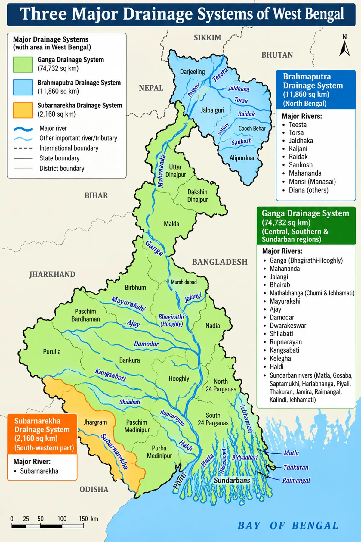
Drainage System of West Bengal: The drainage network of West Bengal is a fascinating web of streams, rivers, and lakes that sculpt the landscape, dictate agricultural fertility, and drive the economy.
The way these rivers flow across the state is primarily shaped by three natural forces: the topography of the land, the gradient or slope, and the nature of the underlying rocks (whether they are hard or soft).
Geographically, West Bengal is divided into three major drainage systems, each playing a unique role in the state’s hydrology:
- The Ganga Basin (including the Sundarban Area): Covers a massive 74,732 sq km.
- The Brahmaputra Basin: Spans 11,860 sq km and accounts for nearly 14% of the state’s geographical area.
- The Subarnarekha Basin: A smaller but vital southwestern system covering 2,160 sq km.
The Ganga Drainage System
The Ganga Basin is the largest drainage system in West Bengal. It serves as the primary hydrological artery for the central, southern, and deltaic regions of the state.
Origin and Journey of the Mighty Ganga
The Ganga begins its journey high up in the Himalayas around an altitude of 7,000 metres, where its two holy headstreams—the Bhagirathi and the Alaknanda—merge at Dev Prayag. The river descends onto the plains at Rishikesh, moving through Uttarakhand and Uttar Pradesh, where it meets its largest tributary, the Yamuna, at Allahabad.
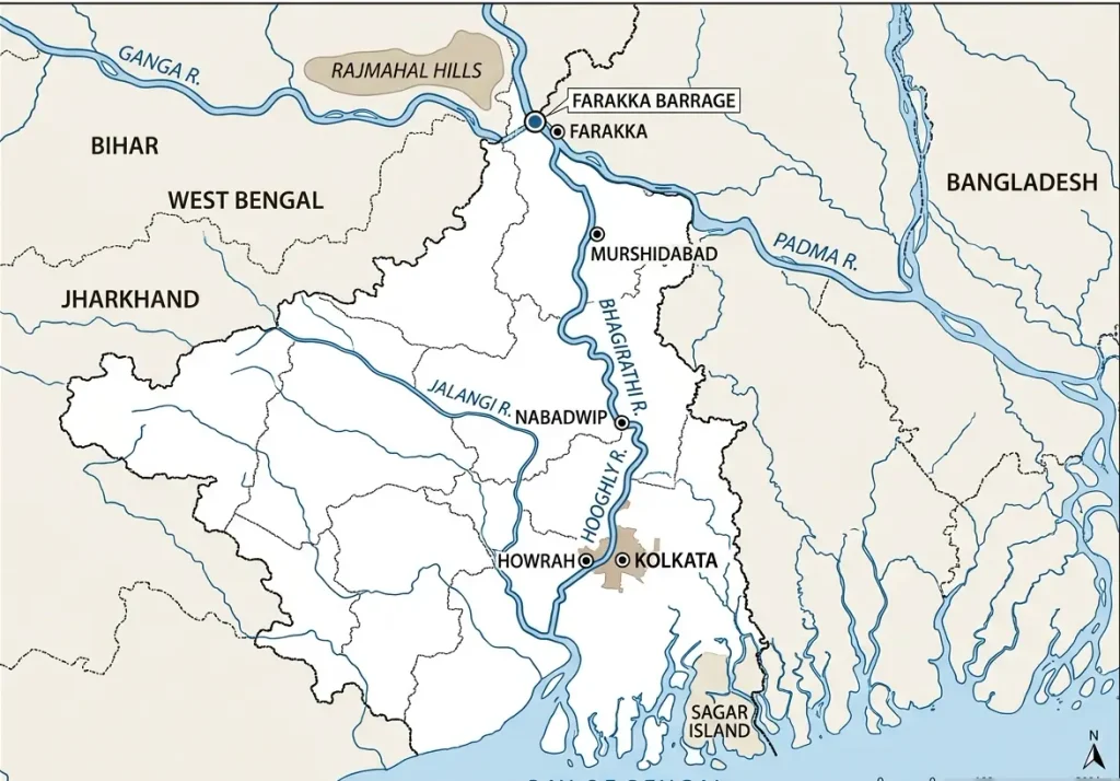
After flowing through Bihar and picking up the Kosi River, the Ganga reaches West Bengal near Rajmahal. It swings around the Rajmahal Hill range and heads south. Approximately 40 km below Farakka, the river undergoes a major bifurcation:
- The Padma: The left branch, which flows eastward into Bangladesh.
- The Bhagirathi: The right branch, which continues southward through West Bengal.
The Bhagirathi–Hooghly Network
The Bhagirathi is the main river of West Bengal and acts as the primary drainage lifesaver for the southern districts. It cuts Murshidabad district into two distinct halves. On its right bank, it receives the Bagmari-Pagla, Mayurakshi, and Ajay rivers. On its left bank, just upstream of Nabadwip, it meets the Jalangi.
From Nabadwip onwards, the river is known as the Hooghly. The Hooghly flows past major urban and industrial centers like Baharampur, Chinsura, Chandannagar, Srirampur, Howrah, and Kolkata, before emptying into the Bay of Bengal near Sagar Island.
Central and Eastern Tributaries
- The Padma River: After crossing into Bangladesh, it meets the Brahmaputra at Goalundo.
- The Mahananda River: Originating from Ghoom near Darjeeling at the northern tip, it travels south and bifurcates at Barsoi (Bihar) into the Fulahar channel and the Mahananda channel, the latter returning to drain parts of West Bengal.
- The Jalangi and Bhairab Rivers: Both are historic distributaries of the Padma. While mostly dry (“dead rivers”) for much of the year, they fill with overflow during the monsoon season. The Jalangi joins the Bhagirathi at Nabadwip.
- The Mathabhanga–Churni–Ichhamati System: The Mathabhanga breaks off from the Padma, flowing briefly through the Nadia district before splitting into two. The western branch becomes the Churni (which connects to the Bhagirathi), while the eastern branch forms the Ichhamati, a tidal river heavily sustained by ocean washouts.
Western Plateaus and Plains Tributaries
- The Mayurakshi–Babla System: The Mayurakshi springs from the Santhal Parganas highlands and stands as the principal river of the Birbhum district. In its lower stretches, it feeds several spill channels (Manikarnika, Kana Mor, Gambhira) into the Hijol Beel wetland of Murshidabad. The outlet of this wetland forms the Babla River, which drains directly into the Bhagirathi.
- The Ajay River: Originating near Deoghar in Jharkhand, it feeds into the Bhagirathi with the help of its main tributaries: the Hinglow, Kunoor, Pathro, and Jayanti.
- The Damodar River: Famously known as the “Sorrow of Bengal” due to historical flash floods, its fierce waters are now managed by the Damodar Valley Project. It originates in the Palamau Hills of Jharkhand and splits at Beguhana. The primary flow enters the Mundeswari channel to join the Rupnarayan, while the flood-carrying Amta channel empties straight into the Hooghly.
- The Dwarakeswar–Shilabati–Rupnarayan System: Born in the highlands of Purulia, the Dwarakeswar joins the Bankura-born Gandheswari near Bankura town. Further downstream, it merges with the Shilabati River (also from Purulia) to create the wide Rupnarayan River, which eventually connects with the Hooghly system in Purba Medinipur.
- The Kangsabati–Keleghai–Haldi System: The Kangsabati (or Kasai) leaves Purulia and gathers water from the Kumari, Bhairab Banki, and Tarafeni rivers. It splits into the Old Cossye (Palaspai Khal) and the New Cossye. The New Cossye merges with the Kaliaghai River (which starts in Jhargram) to form the Haldi River, a crucial commercial waterway that dumps into the Hooghly at Haldia.
The Sundarban Drainage System
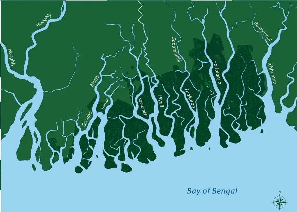
The southernmost portion of the Ganga Basin is defined by a dense labyrinth of interconnected, tidally influenced estuaries and rivers. Major water channels include the Matla, Gosaba, Saptamukhi, Hariabhanga, Piyali, Thakuran, Jamira, Raimangal, and Kalindi. These streams experience massive daily water level shifts driven completely by the tides of the Bay of Bengal.
The Brahmaputra Drainage System
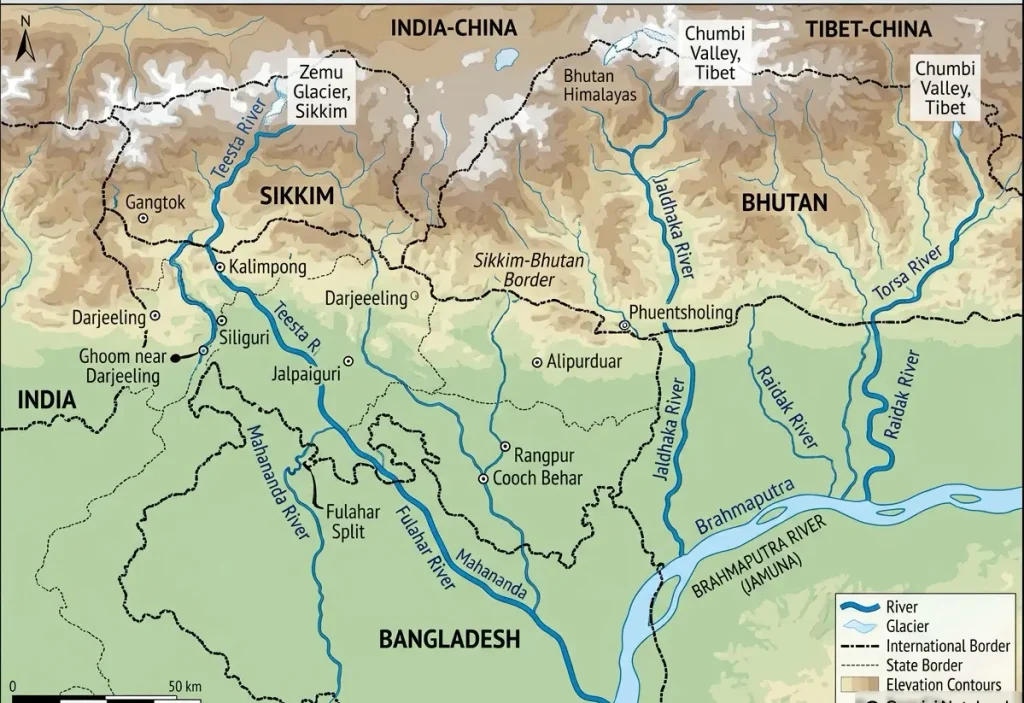
The northern portion of West Bengal (the Terai and Dooars regions) is dominated by the Brahmaputra Basin. These rivers originate in the high-altitude glaciers and lakes of Sikkim, Bhutan, and Tibet, flowing rapidly southward down steep mountain slopes before flattening out into North Bengal and traveling into Bangladesh to meet the Brahmaputra.
The Teesta River
Known as the “Mighty River of North Bengal,” the Teesta originates from glaciers in North Sikkim at an astounding 6,400 metres. It is formed by the confluence of the Lachen and Lachung rivers at Chungthung.
The Teesta cuts through the mountains and enters West Bengal at Rangpo. Along its path, it receives its main tributaries, the Great Rangit and Rammam, both of which serve as natural geographic borders between West Bengal and Sikkim.
The Torsa River
The Torsa begins its journey in the Chumbi Valley of southern Tibet at an elevation of 7,065 metres. It flows through Bhutan before entering the plains of West Bengal, cutting directly past Cooch Behar town. After joining with the Kaljani and Raidak-I, the combined system discharges into the Brahmaputra at Rangpur in Bangladesh.
The Jaldhaka River
Arising from Bitang Lake in Sikkim at an altitude of 4,400 metres, the Jaldhaka winds through Sikkim, Bhutan, and West Bengal. It collects numerous mountain streams before emptying into the Dharala River, which ultimately funnels its way into the Brahmaputra within Bangladesh.
The Subarnarekha Drainage System
The Subarnarekha Basin is the smallest independent drainage network in West Bengal, sitting in the extreme southwestern corner of the state.
Course and Significance
Unlike the other systems, the Subarnarekha does not merge into the Ganga or Brahmaputra within the state’s boundaries. It enters West Bengal from Jharkhand, flows through the state for a brief distance, and then exits into Odisha before reaching the Bay of Bengal. It is a vital water resource for the dry, rocky crags of the southwestern plateau fringe.
Drainage System of West Bengal: Summary
The following table outlines exactly how West Bengal’s complex river networks link together to form its major waterways:
| Initial Streams / Components | Point of Confluence / Event | Resulting River System |
|---|---|---|
| Bhagirathi + Alaknanda | Dev Prayag | Ganga River |
| Ganga Bifurcation | 40 km below Farakka | Padma (Left Branch) & Bhagirathi (Right Branch) |
| Bhagirathi + Jalangi | Near Nabadwip | Hooghly River |
| Dwarakeswar + Shilabati | Western Plains | Rupnarayan River |
| New Cossye + Kaliaghai | Midnapore Plains | Haldi River |
| Mathabhanga Split | Nadia District Boundary | Churni River & Ichhamati River |
| Lachen + Lachung | Chungthung (Sikkim) | Teesta River |
| Torsa + Kaljani + Raidak-I | Bangladesh Borderlands | Brahmaputra System Outlet |
Drainage System of West Bengal: MCQs
1. Which river basin covers the largest geographical area in West Bengal?
- A) Brahmaputra Basin
- B) Ganga Basin
- C) Subarnarekha Basin
- D) Mahananda Basin
- Answer: B (It spans 74,732 sq km).
2. At which place do the Bhagirathi and Alaknanda rivers meet to form the Ganga?
- A) Rishikesh
- B) Allahabad
- C) Dev Prayag
- D) Farakka
- Answer: C
3. Around how many kilometres below Farakka does the Ganga bifurcate into the Padma and Bhagirathi?
- A) 10 km
- B) 25 km
- C) 40 km
- D) 165 km
- Answer: C
4. Which river joins the Bhagirathi near Nabadwip, after which it is known as the Hooghly?
- A) Ajay
- B) Mayurakshi
- C) Jalangi
- D) Churni
- Answer: C
5. Which wetland pocket in Murshidabad receives water from the Mayurakshi spill channels before discharging into the Babla River?
- A) Bitang Lake
- B) Hijol Beel
- C) Ahiran Beel
- D) Motijheel
- Answer: B
6. The confluence of which two rivers forms the Rupnarayan River?
- A) Dwarakeswar and Shilabati
- B) Kangsabati and Keleghai
- C) Lachen and Lachung
- D) Churni and Ichhamati
- Answer: A
7. The Haldi River is formed by the combined flow of which two river branches?
- A) Old Cossye and Palaspai Khal
- B) Dwarakeswar and Shilabati
- C) New Cossye and Kaliaghai
- D) Torsa and Kaljani
- Answer: C
8. What is the total length of the Ganga River within the borders of West Bengal?
- A) 1,450 km
- B) 445 km
- C) 570 km
- D) 2,575 km
- Answer: C
9. Which river is famously known as the “Mighty River of North Bengal”?
- A) Torsa
- B) Teesta
- C) Jaldhaka
- D) Mahananda
- Answer: B
10. The Torsa River originates from which of the following regions?
- A) Chumbi Valley, Southern Tibet
- B) Bitang Lake, Sikkim
- C) Glaciers of North Sikkim
- D) Palamau Hills, Jharkhand
- Answer: A
11. Which river forms the natural boundary between West Bengal and Sikkim?
- A) Jaldhaka
- B) Sankosh
- C) Teesta
- D) Mahananda
- Answer: C (Along with its tributaries Great Rangit and Rammam).
12. Which river flows into West Bengal from Jharkhand and subsequently leaves the state to enter Odisha?
- A) Damodar
- B) Ajay
- C) Kangsabati
- D) Subarnarekha
- Answer: D
Read more:
West Bengal: State Profile, History, Geography & Demographics
Important details on Physiographic Divisions of West Bengal (7 divisions)